Saturday, October 30, 2021

 I had a great time climbing all over the Rock House in Hocking Hills, Ohio. Hocking Hills is by far one of my favorite places to visit since the first time while I was in college at OU throughout the years and this week as I ventured into the only actual caves at Hocking Hills. The other areas are called caves but they are really out-cropped areas. The Rock House is the only true cave to go into and explore. Below are more photos and a little bit of history. Barb Reckard always told me it wasn't a good trip unless I learned a little history along the way. Thanks Barb for always sending me in the best direction.


This House of Rock has a ceiling 25 feet high while the main corridor is 200 feet long and 20 to 30 feet wide. The cavern was eroded out of the middle zone of the Blackhand sandstone. The resistant upper zone forms the roof and the lower zone forms the floor. Water leaking through a horizontal joint running parallel to the cliff face caused the hollowing of the corridor. This main joint or crack is very visible in the ceiling of the Rock House. A small series of joints run north to south at right angles to the main joint. Enlargement of this series of joints formed the window-like openings of Rock House.

Nature has hewn out of this cliff the Rock House complete with seven Gothic-arched windows and great sandstone columns which bear its massive roof. As one might imagine, Rock house was used for shelter by past visitors. Hominy holes, small recesses in the rear wall of Rock House, served as baking ovens for Native Americans using the cave. By building a fire in the small recesses, the rock became heated on all sides, and food could be bakes in this crude manner. Further evidence of past use is the presence of chiseled out troughs or holding tanks found in the stone floor. When rainfall is abundant, springs of water permeate through the porous sandstone and flow into these troughs fashioned by man and, when full, continue across the floor and out of the windows. In this way, residents were able to maintain a small water supply in Rock House. According to local folklore, other not so welcome visitors frequented Rock House. Robbers, horse thieves, murderers and even bootleggers earned Rock House its reputation as Robbers Roost.


Tuesday, October 26, 2021

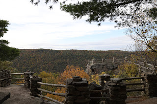
 A few more photos and information from Cooper's Rock. I always marvel seeing the work of the CCC during the Great Depression. These hard working folks had very little after returning from a war that left them depleted of not only material belongings but for many, even their mental ability to think. The CCC camps and work helped them learn new trades and for many the respect and dignity they should have been rewarded just for being able to come home after what they had to endure. They built a lasting beauty in WV that I believe may never be equaled. 

Coopers Rock State Forest is named for Coopers Rock, a series of sandstone cliffs above the Cheat River Gorge. Legend has it that a fugitive hid near what is now the overlook. A cooper by trade, he continued to make and sell barrels from his mountain hideout. During the 1800s the iron industry flourished in the area that is now Coopers Rock. Today the remains of the Henry Clay Furnace – the first steam-powered blast furnace in western Virginia – is a popular hiking and biking destination in the forest. The forest proper was established in 1936. Many of its structures, including the main overlook, picnic shelters and superintendent’s house, were built by the Civilian Conservation Corps during the Great Depression. Eleven of these structures have been listed on the National Register of Historic Places.


Saturday, May 8, 2021

More From Sandstone Falls


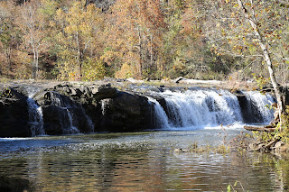
 Sandstone Falls is beautiful anytime of year but these just happen to be Fall photos because that's when I'm in the area the most. These falls are part of the newest National Park in the US The New River Gorge National Park and Preserve in southeastern WV. This is the largest waterfall on the New River where the river spans 1500 feet and the river drops 10 to 25 feet. The state of WV has done a fabulous job in placing boardwalks around the falls so everyone can get a chance at the beautiful views. The falls form the starting line for the New River's final rush through the New River Gorge to its confluence with the Gauley River to form the Kanawha River. 

Thursday, May 6, 2021


 I visit this spot in WV at least once a year and usually in the Fall. It's one of my favorite spots in the state and I think everyone should see it at least once in their life. How many have been there and where am I?

Wednesday, April 28, 2021

more from Gauley Bridge


Gauley Bridge was once, like many communities in WV, a very vibrant town. The name Gauley Bridge dates from the early 1820's when a wooden covered bridge carried important goods and services across the James River and  Kanawha Turnpikes across the Gauley River and into the Kanawha Valley. The village that sprang up was of strategic significance during the Civil War. 

Tuesday, April 27, 2021


 Photo was taken in April of 2021 at Gauley Bridge, WV. 

Gauley Bridge is in Fayette County, WV and as of 2010 had about 600 people living in the community. The New and Gauley Rivers combine here to form the Kanawha River. This area is filled with tourists each year as they travel Rt. 60, The Midland Trail, which crosses the state from east and west from Huntington to points close to the Virginia border. Interstate 64 is now the quick route to follow into White Sulphur Springs but before the Interstate Rt. 60 was the Rt. 66 of WV. Hawk's Nest State Park is about mid-way on the journey. 
This view of the confluence of the Kanawha River shows the popular islands that house a vacation home on one island and the three crosses on another. A ferry system was used many years ago to place the first home on the island which was a bus. It was a full-time home at first and is now a vacation home. I'm sure many out there know more history so let's have some comments.